
The Area: A Brief Water History
A Brief Water History of the San Luis Valley
The San Luis Valley in southern Colorado covers nearly 8,000 square miles at 7,600 feet above sea level – the largest high mountain desert in North America. The “Valley” is bordered by the Sangre de Cristo Mountains to the east (some reaching over 14,000 feet in elevation) and the San Juan Mountains to the west. These mountain peaks hoard moisture-laden clouds and leave precious little precipitation to fall on the valley floor – only about 7-8 inches annually. Melting mountain snows feed the Rio Grande River (the third longest in the U.S.) as it flows through the valley and then southward toward New Mexico and the Texas/Mexico border.
The San Luis Valley is big. It extends more than one-hundred miles from north to south, and about sixty miles wide from east to west. Around 500,000 years ago, the valley was covered by a huge lake (today known as Lake Alamosa) which was two-hundred feet deep in some locations. The ancient lake eventually dried up and left the expansive flat valley we see today. Lake Alamosa also deposited underground sediment layers which today hold groundwater recharged in the valley of the Rio Grande River.

Year 1852
In 1852, the first permanent irrigation system, constructed by residents of the newly established town of San Luis – was an acequia called the San Luis Peoples Ditch, which today is the oldest water right in continuous use in Colorado. That same year, the US Army constructed Fort Massachusetts (later renamed Fort Garland) as more settlers arrived to homestead the fertile valley lands. In 1878 the town of Alamosa was established with the arrival of the Denver & Rio Grande Railroad. Another person to arrive was Theodore C. Henry.
Late 1800s
In the late 1800s, Colorado became well-known around the world for the success of its agricultural colonies, particularly the Union Colony at Greeley and the Chicago-Colorado Colony of Longmont along the Front Range. These settlements were well advertised and generated great interest in Europe, particularly in England and Holland. T.C. Henry was a land promoter and irrigation developer from Denver (by way of Kansas) and took full advantage of the circumstances.
In 1892, the Holland American Land and Immigration Company of Utrecht, Holland, (representing hundreds of potential Dutch settlers) sent an agent to the United States to select sites for new agricultural colonies. Eventually a tract of land was chosen in the San Luis Valley because of available irrigation water and excellent railroad facilities – and through the prominent promotion of T.C. Henry.
The Dutch settlers made an agreement with Henry to purchase 15,000 acres under the Empire Canal near Alamosa. The immigrants arrived at Ellis Island in New York Harbor on November 26, 1892, next boarded a train in Hoboken, New Jersey, and four days later arrived in Alamosa. The economy of the Netherlands was depressed, and many farmers had spent their life savings on what must have felt like an interstellar journey for the somewhat desperate travellers.
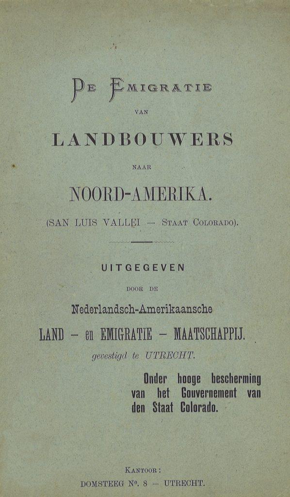

The group of 250 Dutch settlers – including adults and children – were met by a number of people, including the mayor of Alamosa, and were escorted to Armory Hall where the townspeople prepared a lavish meal for the newcomers. Most immigrants were still in their native clothes – peaked caps and wooden shoes. Speeches were made and translated into the Dutch language. The 1,000 residents of Alamosa were happy to have these new settlers among them.
Unfortunately, tragedy struck the Dutch families almost immediately as diphtheria and scarlet fever broke out among the children, and thirteen died. Many immigrant farmers were outraged and felt swindled because their land was poor (it had been described to them as “the Italy of western North America”), irrigation water was sparse, and crops withered due to a lack of water and the short, high altitude growing season. The farmers soon ran out of money and by September 1893, the newly arrived Dutch settlers left for northeastern Colorado, Iowa, or back home to Holland. The only family which remained in Alamosa was that of Adolph Herrsink, who was financially able to carry on – the sole survivor of a tragic failed experiment. T.C. Henry also left the area.
In the 1930s, tragedy struck in the San Luis Valley again. The valley’s irrigated economy had developed during the early 1900s, but national and world events now crippled the area. During the Great Depression, farm prices plummeted and the price of potatoes dropped from $4 per hundredweight in 1920 to $0.35 in 1932. Nearly 10,000 acres of cropland failed in 1934 and thousands were forced to move elsewhere, just like the Dutch settlers 40 years earlier.
Fortunately, the rains returned and irrigation water from the Rio Grande River lifted the local economy in the 1940s. The invention of center pivot irrigation systems in the 1950s – quarter-mile-long pipes elevated on wheels that could irrigate an entire field in a day with the push of a button – changed irrigation in the valley forever. The two enormous aquifers that laid beneath the valley floor for centuries were tapped and supplied irrigation water for center pivot wells constructed in the 1950s and later.


Lake Alamosa
Going back to prehistoric Lake Alamosa, ancient-deposited sediments allowed groundwater to recharge and reside at varying depths beneath the land surface.
The deepest groundwater – called the confined aquifer or Closed Basin, has groundwater at depths of around 800 feet (245 meters).
Other sediment deposits hold groundwater at lesser depths – at around 100 feet (30 meters). This upper layer of groundwater is called the unconfined aquifer and is replenished by recharge from the Rio Grande River and an assortment of unlined irrigation canals in the area. This shallow aquifer supplies about 85 percent of the agricultural well water in the San Luis Valley, with the largest concentration found in the northern part of the valley, near Center and Del Norte, and is served by Subdistrict #1 of the Rio Grande Water Conservation District.
More Recent History
In 1967, the Rio Grande Water Conservation District was formed by the Colorado General Assembly and a vote of residents within its boundaries. The district was created to “protect, enhance, and develop water resources in the Rio Grande River basin.” In 2006, Subdistrict #1 of the Rio Grande Water Conservation District was created to mitigate rapidly declining groundwater levels caused by prolonged drought and increased groundwater pumping.